The conservation and restoration of remnant native woodlands and wetlands to enhance biodiversity and ensure the sustainability of habitats is a priority for many agencies. The task, however, of monitoring and reporting on numerous small areas located on private land across the landscape regularly is onerous.
This article introduces a monitoring framework developed in collaboration with Waikato Regional Council’s (WRC) Spatial Analysis and Modelling Team to continuously monitor 300 000 ha of Significant Natural Areas (SNAs) distributed across three districts of the Waikato region.
The monitoring framework developed uses satellite imagery and an alerts process that allows SNAs to be continuously monitored. The streamlined approach provides users with a tool that identifies and tracks small changes at a regional scale. In the past, many of these areas may have been undetected.
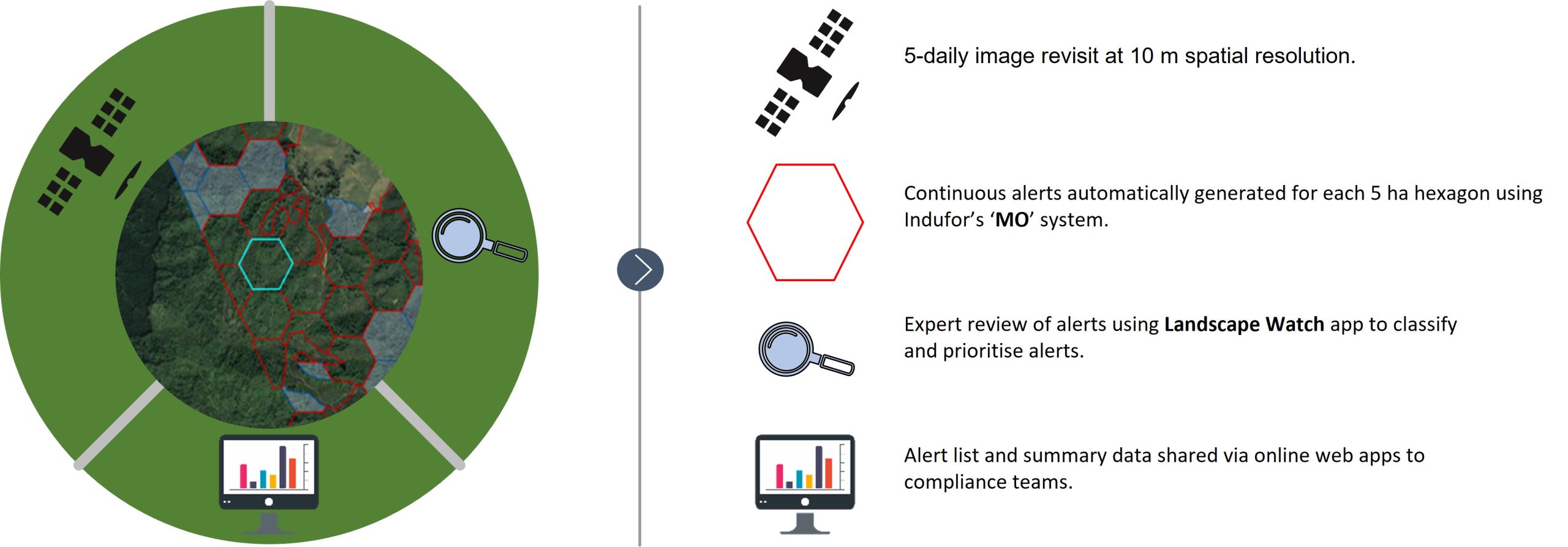
The system is built around Indufor’s ‘MO’ alerts system, which automatically scans each SNA for change. Mo’s scalability and efficiency is enhanced by dividing SNAs into a network of hexagons. As a new satellite image is captured, each hexagon is independently checked for change. If changes are detected, an alert is generated and pushed to the Landscape Watch app for the WRC team to further review.

Indufor’s SNA Monitoring Framework
A key advantage of Landscape Watch is that it allows the reviewer to access the same satellite images used to generate the alert. This streamlines the monitoring processes by effectively scanning each SNA for change, showing only persistent alerts. Alerts can be received in batches or sent in near-real-time as required. WRC receives SNA alerts for each district, each date stamped and plotted over time using a vegetation health index, as shown in the example below.
The standard workflow would involve a reviewer selecting a red line on the graph, which corresponds to an alert. This action also appends the relevant satellite image to the map. In this example, three alerts for the same hexagon have been detected. Multiple alerts provide confidence of genuine change

Indufor’s Landscape Watch Validation Application. The red hexagons show land clearance alerts.
After review, any alerts that require further investigation are summarised and hosted on an online web application (web app). Web apps provide an efficient way of sharing information across different user groups. They do not require specialist GIS knowledge and are easily linked to field applications and mobile devices for verification purposes.
Over the past year, the monitoring system has been developed by Indufor based on feedback received from WRC. Refinements have been made based on this collaboration and to meet WRC’s monitoring aims. The following quote provided by WRC’s Spatial Analysis and Modelling Team summarises the project’s impact.
“The Indufor SNA framework for detecting vegetation clearance has automated and streamlined an otherwise complex, labour-intensive, and prohibitively scaled surveillance task. The system is constantly vigilant and provides operational intelligence within a rapid-response timeframe. The web interface is tuned to the specific requirements of our business process.“
The project has demonstrated the advantage of effectively generating change alerts from repeat visit satellite imagery to improve efficiency and land cover monitoring tasks. Historically, this process would have relied on infrequent manual interpretation of aerial or satellite imagery.
The monitoring framework was built with flexibility in mind, as shown by the following links, which demonstrate how the process can be adapted and used to monitor the success of afforestation projects, compliance of land use activities, or tracking the location and extent of forest harvesting activities
