Resource Monitoring Blog

Team Publications
The following list of publications provides an overview of the work our team has been involved with, spanning forest and landscape analysis, use of different approaches and sensors and time-series monitoring of landscapes and the development of operational monitoring...
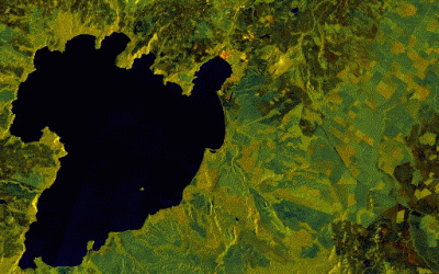
New Zealand-wide RADAR
The frequency of cloud cover in New Zealand presents significant challenges for optical remote sensing - there is a reason NZ is known as the land of the long white cloud! Taking the approach developed for Guyana, New Zealand wide quarterly Sentinel-1 mosaics were...
Simple EO Image Viewer
While satellite (big) data is touted as providing an effective solution for monitoring resources at scale it is often difficult for non-experts or those responsible for monitoring change to easily access and process such data. Indufor has created the following user...
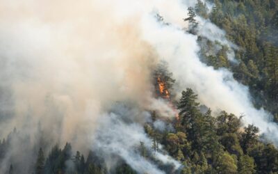
Monitoring and Mapping Bushfires
Record-breaking temperatures and months of drought conditions have fuelled a series of massive bushfires across Australia over the past three months. The total extent of these fires in Queensland, New South Wales (NSW), Victoria, Tasmania and South Australia was in...
Landscape change tracker
One of the most common uses of remotely sensed data is to detect change. Google Earth Engine (GEE) provides a rich open-access catalogue of geospatial information, including optical, meteorological and oceanographic datasets. For forest monitoring, two useful sources...
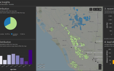
Refreshing Australia’s 2016 NPI Dataset
Plantation statistics like those prepared by Australia’s National Plantation Inventory (NPI) are often published every five years and are compiled from survey information provided by growers and managers. The NPI is used to support strategic forest industry planning...