In late 2020 Indufor in partnership with SKYVUW and Canterbury Aviation purchased a multispectral imaging system to enhance our monitoring capabilities further. The camera, IMU and GPS are mounted on a Cessna which offers a rapid solution for the capture of either discrete or broader areas. A feature of the system design is that it is operated by the pilot alone.
With testing completed the system has been used for a range of applications – forest harvesting, wilding pine detection, bird surveys, fire assessments and monitoring compliance. The solution fits well within Indufor’s landscape monitoring framework that uses satellite imagery to scan the landscape for change.
The airborne solution provides high-resolution images of 2.5 cm and upwards – providing the extra detail often demanded to support verification.
The inclusion of the near-infrared band further assists with separating vegetation types and ground features. By way of demonstration, the following examples showcase the data and applications.
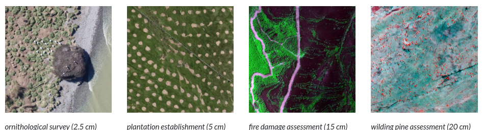
The appeal of an airborne solution is that it is quick to mobilise and flexible enough to cover small or large areas efficiently. For example, a recent capture covered 24,000 ha at a 20 cm spatial resolution within two hours. Alternatively, using the waypoint mode the system can collect imagery across multiple scattered targets with the cameras triggered automatically at pre-determined points.
See our work on novel object detection routines developed in conjunction with Scientists from Scion; which presents an approach that allows the extracting features from the high-resolution imagery.