In 2009, Indufor and Durham University began developing Guyana’s forest monitoring system alongside the Guyana Forestry Commission. The outcome is an operational national monitoring system that reports deforestation at one-hectare scale. The forest change record spans ten years, and the information produced supports Guyana’s resource monitoring efforts.
A further, but yet untapped, potential is the unique research opportunity the dataset offers. This rich temporal record provides a highly accurate reference that supports the evaluation of new detection methods, image datasets and other forest change products (publications).
A recent joint publication with the University of Maryland evaluated the potential of Global Forest Change datasets created by UMD to assist countries with national forest measuring, reporting and verification (MRV) requirements.
The Global Map baseline is created using MODIS and is then re-sampled to 30 m Landsat imagery. It nominally classifies areas as forest if they exceed 30% canopy cover and can reach 5 m in height. The Global Forest Change datasets provide forest loss and gain since the baseline.
The authors note that while the value of the Global Forest Change data is tremendous, it should be used with care, especially in countries like Guyana that have large areas of forest cover and low levels of deforestation.
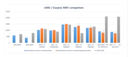
This point is illustrated by the bar chart, which compares the different levels of forest loss (ha) from 2001 to 2017. Guyana’s national wall-to-wall map provides a robust source of reference as over the years has been the subject of numerous audits.
One of the most interesting findings is that while the Global Map provides a good overview of where change is occurring, the map does require calibration to account for differences in forest types, transition and deforestation patterns. In this study, the closest match was achieved after applying a canopy cover threshold of 94%. Also, on closer inspection, annual differences can be considerable.
A novel feature of Guyana’s forest monitoring system is the inclusion of a sample-based approach, which uses a multispectral camera mounted to a Cessna to capture high spatial resolution transects. The results relate well (the orange bar) to the national map, offering an efficient and workable method for estimating forest change.
Guyana represents a handful of countries that have entered into results-based payment agreements designed to protect and conserve the nation’s forests. Over time, the benefits of data produced by the forest monitoring system have evolved to represent one of the most comprehensive and detailed records of temporal forest change within the Amazon region.


